Image Gallery
Gallery
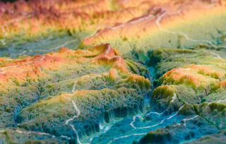
Illinois Watershed Model
Media Details
Created 2/24/2004
This image focuses on one part of a larger model of the Illinois state watershed. The colors are mapped to the height of the terrain - which has been exaggerated 30x for the purpose of this model - while the white lines represent the boundaries of the various watersheds throughout the state. From this vantage point, the camera is looking northeast towards what would be the Peoria area. The entire model measures roughly 1m x .75m in size and was assembled from pieces produced on the VMIL's ZCorp Z406 3D printer. The parts were hardened with paraffin for eventual mounting onto a display board for the Illinois State Water Survey. The photograph was obtained using the Canon EOS-1Ds digital camera, and lit using the ITG's portable light kit.
Credits
- Benjamin Grosser , ITG, Beckman Institute
- Kingsley M. Allan , Illinois State Water Survey