Image of the Week Gallery
Applications of GIS and Geophysics to Subsurface Archaeological Exploration at the Champagne Springs Ruins Site, Colorado
Media Details
Created 12/6/2005
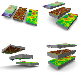
Preservation of prehistoric structures and the physical and cultural amenities contained within is of paramount interest to Native Americans and to archaeologists who excavate, study, and interpret artifacts. Advances in mapping and modeling of ruin sites can be attributed to non-invasive, interdisciplinary approaches to archaeological exploration, often using precision geodetics, geophysical, geological, and geographical studies and techniques. The Champagne Springs Ruins represents an era in prehistory little studied in the Four Corners area of the Colorado Plateau Region. GIS and Geophysics offers insight, without disturbing the substrate, in interpretations of the structural and cultural attributes of this Ancestral Puebloan cultural site. The model shown here represents a small part of this archaeological exploration endeavor. Buried archaeological structures are often exemplified in the overlying surface topography. At the Champagne Springs Ruins, where wind blown loss has long since covered the structural amenities of this ancestral Puebloan community, subtle details of the past become readily discernible following a detailed topographic survey. Over 8000 elevation points contribute to the sites 160 acres, collected using survey-grade Global Positioning Systems and Total Station methodologies. Here, the top-most layer of the model represents a part of that topography. Using a Portable Cesium Magnetometer / Gradiometer, acquisition of vertical magnetic gradient across a 20m x 40m plot, permitted plotting and 3D modeling of complex magnetic anomalies using Maya and the ZPrint software. The second layer of this model represents the vertical magnetic gradient for this area. Several discrete anomalies indicate numerous pit and wall structures exemplified in the overlying topography. Supplemental to the gradient survey, conductivity anomalies were produced (lowest layer in the model) using electromagnetic induction techniques. Pattern recognition using color-differentiation and topography indicated areas of potential archaeological interest and provided an insight as to where to place excavation segments for the 2005 summer field season. Clearly, 3-dimensional modeling offers greater insight as to what may lie beneath the substrate, particularly when complex geophysical and topographic data sets are limited when viewing such data in two dimensions. The renderings pictured here were created from the original data by Alex Jerez, using the Maya animation package. The models will also be printed on the VMIL's Z406 3D printer as a set of stackable layers. The models will be treated with epoxy to harden the surfaces for handling and display. Additional people who worked on this project include: Vincent P. Gutowski, Eastern Illinois University; Harvey Henson, Southern Illinois University; Greg Byer, Mundell & Associates; Don Dove, Mitchell Springs Ruins Group
Credits
- Steven M. Di Naso , Indiana State University and Eastern Illinois Unversity
- Alex Jerez , ITG, Beckman Institute